About me
Bookshop

Get new posts by email.

About me

Photo-a-day 210: Military Vehicle Museum

20120728-225858.jpg

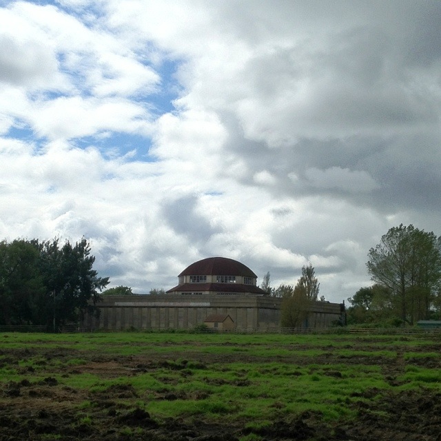
This very distinctive building in Newcastle’s Exhibition Park was originally a temporary pavilion – a “palace of the arts” – in the 1929 North East Coast Exhibition. It proved so distinctive and popular that it was retained and used for a variety of purposes over the years. It’s now Grade II listed.

It’s most recent use was as a Military Vehicle Museum, but the deteriorating state of a temporary building that had far outlasted its designed lifespan led to its closure in 2006. Since then, it’s future had looked uncertain, as the abandoned building deteriorated more and more.

Yet, in May, its future was secured after the building was sold to Shepherd Offshore Ltd who reportedly intend to renovate the building into a museum of horse-drawn carriages and vintage vehicles. It’s great news that the building is to be saved, but I do wonder quite how popular a museum with those contents will be…!

This post was filed under: Photo-a-day 2012, .

Photo-a-day 208: Kittiwake waste

20120726-160342.jpg

I’ve mentioned Newcastle’s quayside kittiwakes before – they’re very controversial because although ornithologists argue that their presence is valuable, they make a heck of a mess around the Tyne Bridge, on which they nest. The hanging sign outside this quayside bar provides a graphic demonstration of the unpleasant mess they liberally spread.

This post was filed under: Photo-a-day 2012, , , .

Photo-a-day 203: Ex-Rock

20120721-094615.jpg

This is Northern Rock’s flagship branch on Northumberland Street in Newcastle – as previously featured ad nauseam on 24hr news in 2007, when there was a run on the bank. It’s just finished its rebrand to Virgin Money – though it’s nice to see that they’ve left the distinctive clock in place.

This post was filed under: Photo-a-day 2012, , , .

Photo-a-day 202: Newcastle’s Town Moor

20120720-232037.jpg

This is Newcastle’s Town Moor at dusk.

The Town Moor is very close to the city centre: certainly no more than a ten minute walk away. It’s one of the largest urban green spaces in the UK: it’s bigger than London’s Hyde Park and Hampstead Heath combined.

The Freemen of the city regularly exercise their right to graze cattle on the moor, making it surely one of the closest pieces of working farmland to a city centre in the UK. This leads to all sorts of student tales of cows being lead to unlikely places within the city, which one has to hope are apocryphal!

As it happens, the grazing rights of the Freemen also extend to St James’ Park. This could cause LOCOG and the IOC one or two headaches should the Freemen choose to exercise their legal right during the upcoming Olympics – I suspect it could prove somewhat disruptive to football matches!

The usage of the Town Moor is governed by its very own Act of Parliament: the Newcastle-upon-Tyne Town Moor Act 1774, given royal assent by King George III. This is perhaps the only thing that Newcastle owes to a Tory government!

The Act was most recently updated in 1988 – also, of course, under a Tory government (or at least its modern equivalent) – though curiously the city loses the hyphens in its name in the title of the Newcastle upon Tyne Town Moor Act 1988. This legislation mandates that “the Town Moor shall be maintained as an open space in the interests of the inhabitants of the city … to afford air and exercise for the enjoyment of the public” – which is nice to know!

This post was filed under: Photo-a-day 2012, .

Photo-a-day 198: Great North Road

20120716-204859.jpg

The Great North Road was the original stage coach route from London to Edinburgh via York, beloved by Dick Turpin and his highwayman colleagues. This is the bit that goes through Gosforth in Newcastle (which is a bit far north for Dick Turpin, but I’m sure he had friends up north…!)

In 1921, the Ministry of Transport designated the Great North Road as the A1. The bit of the Great North Road shown above remained part of the A1 until 1988, when the Western Bypass was built. Of course, these days the A1 is but a small part of the E15 which runs all the way from Inverness in Scotland to Algeciras, right at the bottom of Spain. Even Black Bess would struggle with a ride that long!

This post was filed under: Photo-a-day 2012, , .

Photo-a-day 196: Grand Hotel

20120714-184316.jpg

This is Newcastle’s former Grand Hotel, built in 1891. I’m not sure when it stopped being a hotel, but it now houses a Health Fayre sandwich shop, a branch of Blackwell’s, a Campus Coffee shop and Newcastle University accommodation.

One interesting conundrum about this building is its location. The road you can see running in front of the shop changes at some point from Percy Street (to the left of this picture) to Barras Bridge (to the right).

The Grand Hotel building is listed by the Council (and the architects’ original plans) as being located at 1-24 Barras Bridge. Yet Health Fayre, Blackwell’s, and Campus Coffee – which are all located within the building – are listed being on Percy Street. However, the Newcastle University accommodation situated above these shops, and whose entrance lies between them, is listed as being on Barras Bridge.

So there’s the intriguing reality of several doors located next to each other on the same side of the same building, with the middle one listed as being on a different street to the others!

I’m glad I’m not a postman!

This post was filed under: Photo-a-day 2012, , .

Photo-a-day 192: Newcastle’s town wall

20120710-175452.jpg

This is a bit of Newcastle’s ancient town wall – specifically, the Durham Tower bit. The wall was built in the 13th and 14th centuries, and was once 2 miles long, 2m thick, and over 7m high. There were 17 towers like this one, all within shooting distance of each other to repel attackers. The construction of the wall was funded through a special tax – a murage – which was levied for a hundred years.

The wall kept the town reasonably well protected from invaders, seeing off attacks from David II of Scotland and the Earl of Douglas among others. By the 18th century, the wall had fallen into disrepair, and Scottish armies were able to invade Newcastle a couple of times. By the late 18th century bits of it started to be knocked down, because it started to get in the way.

These days, it’s a scheduled ancient monument which is also the home to a notable literary landmark: Morden Tower, where many great 20th century poets came – and still come – to read their work. Allen Ginsberg, Ted Hughes, Basil Bunting, and Seamus Heaney are just four of the hundreds of previous poetic visitors! It’s also the place where the band Whitehouse once gave a performance in which the entire audience walked out. I don’t think that’s ever happened to any of the poets!

This post was filed under: Photo-a-day 2012, , .

Photo-a-day 190: Ouseburn and a foxglove

20120708-205935.jpg

Today’s photo shows another bit of the Ouseburn, on its meandering path from somewhere near Newcastle Airport to the Tyne.

I’ve featured various bits of the Ouseburn in the last 190 days, and Wendy reckons it’s now become boring and repetitive. She suggested I photograph and feature this foxglove:

20120708-210204.jpg

So two for the price of one today: the Ouseburn and a foxglove!

This post was filed under: Photo-a-day 2012, , , .

Photo-a-day 187: Gateshead Millennium Bridge tilted

20120701-172805.jpg

I’ve featured the Millennium Bridge a few times: once with bollards, once during the removal of the bollards, and once without them. But today is the first time I’ve featured it tilted!

It cost £22m to build, and tilted for the first time in 2001. It’s so energy efficient that it costs just £3.60 in electricity to open. One thing that many people don’t realise is that the tilting of the bridge has a secondary function, beyond letting ships pass: it tips any litter dropped on the bridge into special traps, making the bridge uniquely self-tidying!

This post was filed under: Photo-a-day 2012, , , .

Photo-a-day 183: Bungee jumping over the Tyne

20120701-165052.jpg

You’ll need a sharp pair of eyes to spot the figure on the end of this bungee rope, right in the centre of the photo.

You can see rather more easily the Sage, the Tyne Bridge (complete with Olympic rings), the Castle Keep, and St Nicholas’s and St Mary’s cathedrals, all of which I’ve featured previously!

You can also see the quayside’s Sunday market in full flow; a bit of the 136 year old Swing Bridge, whose predecessors date back some 1,800 years or so to the Roman Pons Aelius; a smidgen of Robert Stephenson’s High Level Bridge, from which hundreds of people watched the Great Fire of Newcastle and Gateshead in 1854; and the roof of HMS Calliope, the stone frigate on the Gateshead bank of the Tyne.

You can’t see the talented young musicians performing in the North East Youth Steel Pan Festival, part of ¡Vamos! 2012. This festival was actually my reason for visiting the quayside this afternoon, but inclement weather moved it indoors, which would’ve made a fairly dull photo. So you’ve got a bungee jumping nutcase from outside instead!

This post was filed under: Photo-a-day 2012, , , , .


The content of this site is copyright protected by a Creative Commons License, with some rights reserved. All trademarks, images and logos remain the property of their respective owners. The accuracy of information on this site is in no way guaranteed. Opinions expressed are solely those of the author. No responsibility can be accepted for any loss or damage caused by reliance on the information provided by this site. Information about cookies and the handling of emails submitted for the 'new posts by email' service can be found in the privacy policy. This site uses affiliate links: if you buy something via a link on this site, I might get a small percentage in commission. Here's hoping.